The Canyons...
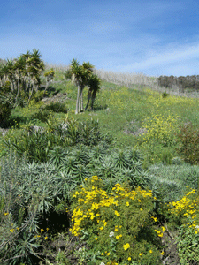
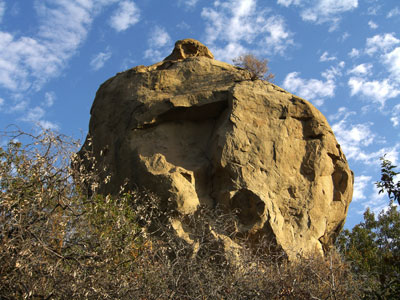
Malibu Canyons/Santa Monica Mountains Conservancy, Malibu, CA, 2008 (Photo: K.Anderberg)
Foothills and Canyons Are Shorelines of Land
By Kirsten Anderberg (www.kirstenanderberg.com)
Written May 8, 2009
The foothills of Southern CA are a shoreline between valleys and mountains. The base of these foothills always contain footpaths that have served humans and animals throughout history. At that edge, where land uplifts from the valley floor, life changes. Instead of the terrain of river beds and flat valleys, canyons emerge like tide pool rocks. And water plays as much a part here, in these canyons, as it does in ocean tides. Water melts the foothills, literally, and all buildings directly below them, or built on the foothill slopes themselves, commonly risk mudslide damages. As I write this article, as a matter of fact, there are evacuations throughout Santa Barbara, as wildfires roar through the canyons surrounding that area. Areas that suffer fires, later are more prone to mudslides, it is all a perfect circle. Floods are also common on valley floors and throughout canyons; all water trying to get to the sea. Water on the earth's surface created the canyons and the valley floors of the Southern CA terrain, but something just as powerful underneath the earth has uplifted, tilted, and folded this land as well.

Ridge Route, above Castaic, CA, 2008 (Photo: K.Anderberg)
I love to drive along Ridge Route, up above Castaic. It is an old route that literally straddles the ridge, and it had a big hoopala when it opened long ago. The L.A. Times shows old cars and people in old fashioned clothing piling into cars to drive along Ridge Route for recreation, and several health spas and traveler accommodations also were active back then. It was the best route north prior to I-5 being put in. Ridge Route has many a blind curve, and during the winter, the hills are gooey, running down like chocolate, causing rock and mud slides. The mud can cover the road. There are piles of rock left at the base of these hills, and I have found very interesting rocks and minerals in the piles by the road, including lots of twin-layered gypsum. Also, the exposed hills show a tortured folding of the rocks. And that is the underground activity that made this whole area. From above, on Ridge Route, you can see vast foothills and faults, cattle ranging and hidden aqueducts. Except for the electrical towers, there is nothing but cows, grass and chapparel up on Ridge Route. There are no gas stations, no small liquor stores, no stop lights, there are barely any houses
it is very isolated up on Ridge Route and it is beautiful up there.
Ridge Route, Santa Paula, Santa Monica...

The "pink moment" of sunrise over the Topa Topa Mountains to the north of Santa Paula Valley, CA, 2009 (Photo: K.Anderberg)
Last year I got curious about the foothills of the Santa Paula Valley. With folded foothills on the north and south sides, running east and west, of that agricultural valley's floor, canyons are abundant. There lies a "shoreline" between flat valley floor and the rise of foothills, where canyons serve as doors for human entry. The perfect symmetry of manmade houses and orange groves stops abruptly at the mouth of each canyon in the Santa Paula Valley. Here, bobcats, cougars, rattlesnakes and coyotes replace cars and children. Chapparel and vast green or brown hills, depending on the season, replace sidewalks and stores. Only birds soar where freeway overpasses hover in the city. Foothills and canyons are, for me, a huge part of why I love Southern CA.
I am in love with a lot of canyons in the Los Angeles area. Topanga Canyon and Las Virgenes/Malibu Canyons are corridors between the San Fernando Valley and the Pacific Ocean, crawling up and down the Santa Monica Mountains. Both provide beautiful scenery along the way. Heading to the eastern flank of the San Fernando Valley floor, we hit the Verdugo foothills, leading into Tujunga Canyons and the Angeles National Forest. If you head over the hills to the north of the San Fernando Valley floor, you hit the Santa Clarita Valley basin. Heading to the eastern edge of the Santa Clarita Valley floor, you find oak tree-lined canyons still the same as they were in the days of the "wild, wild west."
"Darkness came on, but I found my way by the trends of the canyons and the peaks projected against the sky..." - John Muir, 1894
Bouquet Canyon...

Bouquet Canyon sandstone rocks, Saugus, CA, 2008 (Photo: K.Anderberg)
Huge sandstone sculptures in Santa Clarita's Bouquet Canyon cast shadows like scary monsters at dusk, with black caves like eyes, or windows in a high rise. Animals emerge with the coming of nightfall, and also at dawn, in the hot Santa Clarita summers. Deer graze the lowlands and snakes and bobcats come out like crabs at low tide to feed.
I have more canyon stories than I could ever contain in one article. Many of my fondest memories of being alone in the quiet solitude of nature involves these canyons surrounding Los Angeles.
As I said, surface water plus geologic energy underneath created this landscape, together. And these areas are true tidal zones and shorelines, so to speak, as the ocean comes inland at different intervals in history too. So not only do canyons and valley floors serve as river paths to the sea, but sometimes when ocean levels rise, oceans back up these same river bottoms and travel up the same canyons that water comes down today. They are corridors for water, and when dry, they become corridors for wildlife and humans.
Ojai and Earthquakes...

Geology along the road heading to Ojai, 2009 (Photo: K.Anderberg)
Along the highway leading into Ojai, there are hillsides that were horizontal layers of ocean floor at one point, and they are now uplifted and tilted vertically to make a
wall. And this is hard to believe, but as I am in the middle of writing this article, we just had a pretty big earthquake! It is May 8, and around 1:40 p.m., I just felt a
strong earthquake. All of a sudden my home began to shudder, and then we had a jolt one way, then a jolt the other, and I was on my feet. I went outside and my neighbor turned
on the news, and we heard that it was a 4.2, centered a few miles east of Ojai, which is just up the road from where I live in Ventura. There is nothing like a good earthquake.
It feels unlike anything else. It is the roller coaster of Mother Nature and makes amusement parks pale in comparison. I have witnessed the devastation of the Sylmar earthquake in 1971, when freeway overpasses hung broken in the air all through the Old Road area, and the Van Norman Dam broke, and 80,000 people had to be evacuated from the North San Fernando Valley floor. Our house was the only house on the hill with the Odyssey Restaurant above Rinaldi Street at the 405 Freeway, and we were high enough to not have to evacuate due to the dam. I was also at the epicenter of the Loma Prieta Quake in Santa Cruz in Oct. 1989.
Somehow, we moved to Northridge, just in time for the 1994 Northridge earthquake, which collapsed our apartment building in 16 seconds. And then I moved back to Seattle, and
thus we were there for the Feb. 2001 earthquake in Seattle which was the biggest quake they had experienced in nearly 40 years. And now I live in Ventura, and Ojai had a large
quake that we felt today, and last week Malibu had a significant quake. Everywhere I go, the earth is shaking, moaning, breaking, snapping, sliding, trying to adjust its skin
and body parts, as it grows and changes. Quakes such as the one I experienced today reminds me that I live in a geologically active area, which as I have acknowledged grew
those beautiful canyons and foothills I love so. When I look at the contorted rocks, and I feel these earthquakes, I am also profoundly moved and humbled. My son said one of the most amazing things he has ever felt was lying on the lawn, as a 9 year old, during hard aftershocks in the 5.0+ range, after the main Northridge earthquake in '94. It really does raise a strange brew of emotions to feel the earth convulse under you. And living a block from the beach, I am always aware that a good quake could move that ocean back over these canyons and foothills into the mountains where it has been before. The San Fernando Valley, the Santa Clarita Valley, the Santa Paula Valley, Ojai, Tujunga, Topanga, they were all under the sea at some point.
Santa Paula...
South side of the Santa Paula Valley, 2009 (Photo: K.Anderberg)
A while back, I ventured to the south of Highway 126 on my way from Castaic to Ventura, heading west. I took Torrey Road along the foothills, through miles of orange and lemon groves, with an occasional avocado orchard or oil drill along the way. I drove past old farm houses, and old adobe houses with cactus in the yard. I saw houses sitting right at the mouths of canyons, and everywhere the landscape bore witness to flooding, both on the valley floor, with all the trees leaning one direction, towards the west, or coming from the hills above during winter rains, taking the path of least resistance. Thus trying to live in buildings butted right up against the wall of a foothill is an inevitable struggle against nature over the years. Since these flood issues are so great, especially at the mouth of a canyon, no matter how small, much of this valley floor and surrounding foothills have gone to agriculture and cattle, thus they are quite rural and quiet compared to the busy San Fernando and Los Angeles Valley floors to the south & east.
Santa Paula Geology...
Foamy rocks line the walls beside the road along the southern foothills of the Santa Paula Valley, 2009 (Photo: K.Anderberg)
Following the southern foothills along the Santa Paula Valley towards the ocean to the west, you will get what amounts to a spectacular geologic "light show" of amazing rocks, some white and foamy-looking, others red and brown, and at other times, layered ocean floor now tilted vertically to form the valley walls.
Bouquet Canyon...
Bouquet Canyon, sandstone ledge with wildife looking at me, 2008 (Photo: K.Anderberg)
Verging on the Mojave Desert, Bouquet Canyon, Placerita Canyon, Rice Canyon, Mint Canyon, all in the Santa Clarita Valley, offer hot, dry canyons for hiking and exploration. Last summer, I did a lot of exploring in Bouquet Canyon. There are beautiful sandstone rocks there, full of wildlife, living not only in the nooks and crags of the rocks, but also in the numerous caves eroded in the rock face. One morning last August (2008), at about 9 a.m., when the sun had come up and warmed the area to above 90 degrees at that point, I looked up and saw an animal above me on a ledge in the rocks. I think it may be a big horn sheep, but if it is not that, it is perhaps a form of a mountain goat. It was a black male, with very large, curved horns. At first, I was enamored with the presence of the sheep, clicking pictures of him, then he looked mad, and all of a sudden, jumped down several layers of the rock so fast, that I was shocked. I had thought he was further away, thinking he would have to maneuver the rocks. But he flew down the rocks as if his feet were magnetic to the rocks. He looked very serious and never took his eyes off me and I quickly got the message, and slowly backed away and left the area. Now, if that had been a mountain lion, I am not sure what I would have done, sans trying to back away as quickly as possible. A little further up Bouquet Canyon, there is also a small waterfall along the roadside on the left side on the way up the canyon from Saugus. (Watch out for the poison oak along the sides of the water!)
The Mojave Desert...

Vasquez Rocks, Agua Dulce, CA - May 16, 2009 (Photo: K.Anderberg)
Heading out of the Santa Clarita Valley, on Sierra Highway or Highway 14 (Antelope Valley Freeway), you head into the Mojave Desert. Vasquez Rocks is a park area right off of
Highway 14, and also Sierra Highway, with very unique rocks, and it is a
nice park to visit. Beautiful rocks on a desert floor there make for a movie set-like landscape out there. These are the foothill areas below the San Gabriel Mountains.

Pearblossom Highway, Pearblossom, CA - May 16, 2009 (Photo: K.Anderberg)
You can drive from the Antelope Freeway/14 or Sierra Highway, to Pearblossom Highway (Highway 138), which takes you into intense portions of
the Mojave Desert. Joshua trees, cactus, and sagebrush against the orange setting sun at dusk is really spectacular out there. But it is brutally hot in spring, summer and fall...so go
prepared with water, etc. Devil's Punchbowl is a wilderness area located off of Highway 138 that is worthy of some time invested. And you can head up
into the Angeles National Forest from Pearblossom Highway by taking N4, or Highway 2, through canyons, going towards Wrightwood after Phelan.
San Fernando Valley...
North Chatsworth Park, rocks in formation of a goddess, 2009 (Photo: K.Anderberg)
In the north end of the San Fernando Valley, Bee Canyon and Aliso Canyons offer hiking. At the western side of the San Fernando Valley is Chatsworth Park which is a foothill area, with hiking trails, as well. I stumbled upon a group of rocks in North Chatsworth Park, beyond a grove of oak trees, that looks remarkably like a woman. I would be amazed if some group of native people did not also notice this resemblance. I am not sure if this group of rocks was carved to make a goddess statue, which seems plausible to me. The triangle at the genital area is an ancient depiction of woman in rock statues, as a matter of fact. I have not been able to find anything written about this "Goddess of Chatsworth Park," nor have I ever seen another picture of it, besides the one I took. I believe research should be invested into this rock, as I believe it may have ancient cultural and spiritual significance. When I was a teen in the 1970's, we used to drive up Zelzah past Rinaldi, and it was a lovely drive through meadows with oaks and a lot of green rolling hills. Now, ticky tacky housing is taking over all of the hillsides. But if you drive on Zelzah, through the dirt road part, back onto the paved road, to the end, you hit an equestrian path that follows the ridge line. Although that canyon is quickly filling up with housing, it still has some striking views of the Valley and is pretty quiet and still, if you just want a quick place to be alone, in the midst of the chaotic Valley.
Up past Sunland and Shadow Hills, where you are apt to find yourself in a car, crawling along behind a group of equestrians riding horses down the side streets, is the
opening to the Tujunga Canyons, leading into the Angeles National Forest. (This canyon was the preferred spot for my sister and myself to cut school in high school.) The canyon
has a lot of small streams and a shallow river with little pools of cool running water, shaded by oak trees, alongside flats of gravel and sand. The mountains surrounding the canyon floor with the streams and river, are lined with evergreen trees and lots of rock walls and rock cabins. The canyon roads wind and climb, and the area has a certain ambiance to it. This canyon is the canyon that water takes to the sea, which is why Sunland, below this canyon, floods commonly. In ancient times, the rise of the mountains landlocked some ocean water behind Tujunga Canyon and if you look at a satellite shot of the area from above, you can clearly see the path the trapped ocean up there took right down to the sea. You can see the carved path easily from the air, and you can see how places along that swath you see from Tujunga Canyon to the sea, deal with flooding as a major issue. It is interesting to me to see how much of this landscape makes geological sense.
Ventura, CA...

Canada Larga, off of Highway 33, Ventura, CA, 2009 (Photo: K.Anderberg)
I took a trip up Canada Larga Avenue, just off of Highway 33, and Ventura Ave. I immediately noticed odd tumbled blocks of brick, rock, and mortar on the sides of the road at
one place where it seems water had previously flowed in a river, it had a sandy bottom and there was a path carved on either side, etc. Later, I learned those tumbled blocks of
rock and mortar are remnants of the old aqueduct for the Buenaventura Mission in its antiquity. The road rambles gently on to lush green pastures in winter, and rolling hills lined with oak trees. The silence in these green hills is stunning. I could hear the birds' wings flapping above me.
Cows gathered in the shade of oak trees and I saw no one the entire time I was out there. Sometimes I had to wait for cows to cross the road, with one bull looking in my driver window as he walked by.

Corral Canyon in Malibu leads to the Pacific Ocean, 2008 (Photo: K.Anderberg)
Foothills and canyons are a huge part of Southern CA. life. Without our "shorelines" of land between land, our lives would be less beautiful. The canyons create habitat for wildlife, birds and plants, and the foothills create a buttress that stops society at its edges, like a gated community for the wild. Natural barriers of water, fire, mud, thick chapparel, and even earthquake activity, have kept these hills more sparsely populated than they would be without such risks, and this natural activity has also kept this area in a somewhat natural state. Even in this place known for its urban centers, peaceful canyons lead in and out of the deserts and to the ocean all around Los Angeles County. Whichever canyons and foothills you choose to explore, I recommend you also check them out at night. Canyons at night are dark and quiet, but for frogs, and crickets, and lots of sounds you don't get in the city. And the stars are brilliant white against a dark sky. The foothills and canyons are not just metaphorically shorelines between lines of land, but they are currently shorelines between people and nature, and that is a good thing.
Malibu Canyons/Santa Monica Mountains Conservancy, Malibu, CA, 2008 (Photo: K.Anderberg)
Foothills and Canyons Are Shorelines of Land
By Kirsten Anderberg (www.kirstenanderberg.com)
Written May 8, 2009
The foothills of Southern CA are a shoreline between valleys and mountains. The base of these foothills always contain footpaths that have served humans and animals throughout history. At that edge, where land uplifts from the valley floor, life changes. Instead of the terrain of river beds and flat valleys, canyons emerge like tide pool rocks. And water plays as much a part here, in these canyons, as it does in ocean tides. Water melts the foothills, literally, and all buildings directly below them, or built on the foothill slopes themselves, commonly risk mudslide damages. As I write this article, as a matter of fact, there are evacuations throughout Santa Barbara, as wildfires roar through the canyons surrounding that area. Areas that suffer fires, later are more prone to mudslides, it is all a perfect circle. Floods are also common on valley floors and throughout canyons; all water trying to get to the sea. Water on the earth's surface created the canyons and the valley floors of the Southern CA terrain, but something just as powerful underneath the earth has uplifted, tilted, and folded this land as well.
Ridge Route, above Castaic, CA, 2008 (Photo: K.Anderberg)
I love to drive along Ridge Route, up above Castaic. It is an old route that literally straddles the ridge, and it had a big hoopala when it opened long ago. The L.A. Times shows old cars and people in old fashioned clothing piling into cars to drive along Ridge Route for recreation, and several health spas and traveler accommodations also were active back then. It was the best route north prior to I-5 being put in. Ridge Route has many a blind curve, and during the winter, the hills are gooey, running down like chocolate, causing rock and mud slides. The mud can cover the road. There are piles of rock left at the base of these hills, and I have found very interesting rocks and minerals in the piles by the road, including lots of twin-layered gypsum. Also, the exposed hills show a tortured folding of the rocks. And that is the underground activity that made this whole area. From above, on Ridge Route, you can see vast foothills and faults, cattle ranging and hidden aqueducts. Except for the electrical towers, there is nothing but cows, grass and chapparel up on Ridge Route. There are no gas stations, no small liquor stores, no stop lights, there are barely any houses it is very isolated up on Ridge Route and it is beautiful up there.
The "pink moment" of sunrise over the Topa Topa Mountains to the north of Santa Paula Valley, CA, 2009 (Photo: K.Anderberg)
Last year I got curious about the foothills of the Santa Paula Valley. With folded foothills on the north and south sides, running east and west, of that agricultural valley's floor, canyons are abundant. There lies a "shoreline" between flat valley floor and the rise of foothills, where canyons serve as doors for human entry. The perfect symmetry of manmade houses and orange groves stops abruptly at the mouth of each canyon in the Santa Paula Valley. Here, bobcats, cougars, rattlesnakes and coyotes replace cars and children. Chapparel and vast green or brown hills, depending on the season, replace sidewalks and stores. Only birds soar where freeway overpasses hover in the city. Foothills and canyons are, for me, a huge part of why I love Southern CA.
I am in love with a lot of canyons in the Los Angeles area. Topanga Canyon and Las Virgenes/Malibu Canyons are corridors between the San Fernando Valley and the Pacific Ocean, crawling up and down the Santa Monica Mountains. Both provide beautiful scenery along the way. Heading to the eastern flank of the San Fernando Valley floor, we hit the Verdugo foothills, leading into Tujunga Canyons and the Angeles National Forest. If you head over the hills to the north of the San Fernando Valley floor, you hit the Santa Clarita Valley basin. Heading to the eastern edge of the Santa Clarita Valley floor, you find oak tree-lined canyons still the same as they were in the days of the "wild, wild west."
"Darkness came on, but I found my way by the trends of the canyons and the peaks projected against the sky..." - John Muir, 1894
Bouquet Canyon sandstone rocks, Saugus, CA, 2008 (Photo: K.Anderberg)
Huge sandstone sculptures in Santa Clarita's Bouquet Canyon cast shadows like scary monsters at dusk, with black caves like eyes, or windows in a high rise. Animals emerge with the coming of nightfall, and also at dawn, in the hot Santa Clarita summers. Deer graze the lowlands and snakes and bobcats come out like crabs at low tide to feed.
I have more canyon stories than I could ever contain in one article. Many of my fondest memories of being alone in the quiet solitude of nature involves these canyons surrounding Los Angeles.
As I said, surface water plus geologic energy underneath created this landscape, together. And these areas are true tidal zones and shorelines, so to speak, as the ocean comes inland at different intervals in history too. So not only do canyons and valley floors serve as river paths to the sea, but sometimes when ocean levels rise, oceans back up these same river bottoms and travel up the same canyons that water comes down today. They are corridors for water, and when dry, they become corridors for wildlife and humans.
Geology along the road heading to Ojai, 2009 (Photo: K.Anderberg)
Along the highway leading into Ojai, there are hillsides that were horizontal layers of ocean floor at one point, and they are now uplifted and tilted vertically to make a wall. And this is hard to believe, but as I am in the middle of writing this article, we just had a pretty big earthquake! It is May 8, and around 1:40 p.m., I just felt a strong earthquake. All of a sudden my home began to shudder, and then we had a jolt one way, then a jolt the other, and I was on my feet. I went outside and my neighbor turned on the news, and we heard that it was a 4.2, centered a few miles east of Ojai, which is just up the road from where I live in Ventura. There is nothing like a good earthquake. It feels unlike anything else. It is the roller coaster of Mother Nature and makes amusement parks pale in comparison. I have witnessed the devastation of the Sylmar earthquake in 1971, when freeway overpasses hung broken in the air all through the Old Road area, and the Van Norman Dam broke, and 80,000 people had to be evacuated from the North San Fernando Valley floor. Our house was the only house on the hill with the Odyssey Restaurant above Rinaldi Street at the 405 Freeway, and we were high enough to not have to evacuate due to the dam. I was also at the epicenter of the Loma Prieta Quake in Santa Cruz in Oct. 1989.
Somehow, we moved to Northridge, just in time for the 1994 Northridge earthquake, which collapsed our apartment building in 16 seconds. And then I moved back to Seattle, and thus we were there for the Feb. 2001 earthquake in Seattle which was the biggest quake they had experienced in nearly 40 years. And now I live in Ventura, and Ojai had a large quake that we felt today, and last week Malibu had a significant quake. Everywhere I go, the earth is shaking, moaning, breaking, snapping, sliding, trying to adjust its skin and body parts, as it grows and changes. Quakes such as the one I experienced today reminds me that I live in a geologically active area, which as I have acknowledged grew those beautiful canyons and foothills I love so. When I look at the contorted rocks, and I feel these earthquakes, I am also profoundly moved and humbled. My son said one of the most amazing things he has ever felt was lying on the lawn, as a 9 year old, during hard aftershocks in the 5.0+ range, after the main Northridge earthquake in '94. It really does raise a strange brew of emotions to feel the earth convulse under you. And living a block from the beach, I am always aware that a good quake could move that ocean back over these canyons and foothills into the mountains where it has been before. The San Fernando Valley, the Santa Clarita Valley, the Santa Paula Valley, Ojai, Tujunga, Topanga, they were all under the sea at some point.
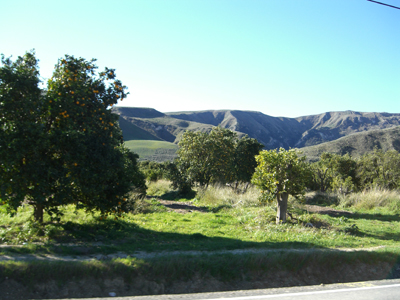
South side of the Santa Paula Valley, 2009 (Photo: K.Anderberg)
A while back, I ventured to the south of Highway 126 on my way from Castaic to Ventura, heading west. I took Torrey Road along the foothills, through miles of orange and lemon groves, with an occasional avocado orchard or oil drill along the way. I drove past old farm houses, and old adobe houses with cactus in the yard. I saw houses sitting right at the mouths of canyons, and everywhere the landscape bore witness to flooding, both on the valley floor, with all the trees leaning one direction, towards the west, or coming from the hills above during winter rains, taking the path of least resistance. Thus trying to live in buildings butted right up against the wall of a foothill is an inevitable struggle against nature over the years. Since these flood issues are so great, especially at the mouth of a canyon, no matter how small, much of this valley floor and surrounding foothills have gone to agriculture and cattle, thus they are quite rural and quiet compared to the busy San Fernando and Los Angeles Valley floors to the south & east.
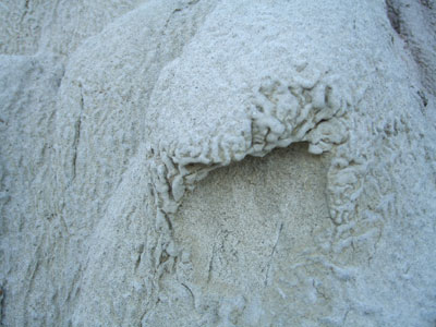
Foamy rocks line the walls beside the road along the southern foothills of the Santa Paula Valley, 2009 (Photo: K.Anderberg)
Following the southern foothills along the Santa Paula Valley towards the ocean to the west, you will get what amounts to a spectacular geologic "light show" of amazing rocks, some white and foamy-looking, others red and brown, and at other times, layered ocean floor now tilted vertically to form the valley walls.
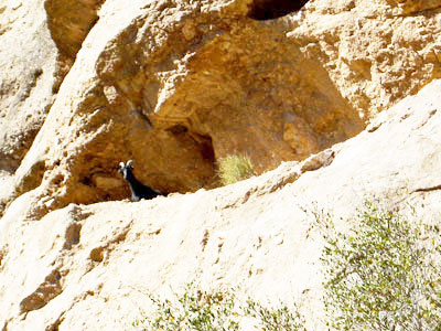
Bouquet Canyon, sandstone ledge with wildife looking at me, 2008 (Photo: K.Anderberg)
Verging on the Mojave Desert, Bouquet Canyon, Placerita Canyon, Rice Canyon, Mint Canyon, all in the Santa Clarita Valley, offer hot, dry canyons for hiking and exploration. Last summer, I did a lot of exploring in Bouquet Canyon. There are beautiful sandstone rocks there, full of wildlife, living not only in the nooks and crags of the rocks, but also in the numerous caves eroded in the rock face. One morning last August (2008), at about 9 a.m., when the sun had come up and warmed the area to above 90 degrees at that point, I looked up and saw an animal above me on a ledge in the rocks. I think it may be a big horn sheep, but if it is not that, it is perhaps a form of a mountain goat. It was a black male, with very large, curved horns. At first, I was enamored with the presence of the sheep, clicking pictures of him, then he looked mad, and all of a sudden, jumped down several layers of the rock so fast, that I was shocked. I had thought he was further away, thinking he would have to maneuver the rocks. But he flew down the rocks as if his feet were magnetic to the rocks. He looked very serious and never took his eyes off me and I quickly got the message, and slowly backed away and left the area. Now, if that had been a mountain lion, I am not sure what I would have done, sans trying to back away as quickly as possible. A little further up Bouquet Canyon, there is also a small waterfall along the roadside on the left side on the way up the canyon from Saugus. (Watch out for the poison oak along the sides of the water!)
Vasquez Rocks, Agua Dulce, CA - May 16, 2009 (Photo: K.Anderberg)
Heading out of the Santa Clarita Valley, on Sierra Highway or Highway 14 (Antelope Valley Freeway), you head into the Mojave Desert. Vasquez Rocks is a park area right off of Highway 14, and also Sierra Highway, with very unique rocks, and it is a nice park to visit. Beautiful rocks on a desert floor there make for a movie set-like landscape out there. These are the foothill areas below the San Gabriel Mountains.
Pearblossom Highway, Pearblossom, CA - May 16, 2009 (Photo: K.Anderberg)
You can drive from the Antelope Freeway/14 or Sierra Highway, to Pearblossom Highway (Highway 138), which takes you into intense portions of the Mojave Desert. Joshua trees, cactus, and sagebrush against the orange setting sun at dusk is really spectacular out there. But it is brutally hot in spring, summer and fall...so go prepared with water, etc. Devil's Punchbowl is a wilderness area located off of Highway 138 that is worthy of some time invested. And you can head up into the Angeles National Forest from Pearblossom Highway by taking N4, or Highway 2, through canyons, going towards Wrightwood after Phelan.
North Chatsworth Park, rocks in formation of a goddess, 2009 (Photo: K.Anderberg)
In the north end of the San Fernando Valley, Bee Canyon and Aliso Canyons offer hiking. At the western side of the San Fernando Valley is Chatsworth Park which is a foothill area, with hiking trails, as well. I stumbled upon a group of rocks in North Chatsworth Park, beyond a grove of oak trees, that looks remarkably like a woman. I would be amazed if some group of native people did not also notice this resemblance. I am not sure if this group of rocks was carved to make a goddess statue, which seems plausible to me. The triangle at the genital area is an ancient depiction of woman in rock statues, as a matter of fact. I have not been able to find anything written about this "Goddess of Chatsworth Park," nor have I ever seen another picture of it, besides the one I took. I believe research should be invested into this rock, as I believe it may have ancient cultural and spiritual significance. When I was a teen in the 1970's, we used to drive up Zelzah past Rinaldi, and it was a lovely drive through meadows with oaks and a lot of green rolling hills. Now, ticky tacky housing is taking over all of the hillsides. But if you drive on Zelzah, through the dirt road part, back onto the paved road, to the end, you hit an equestrian path that follows the ridge line. Although that canyon is quickly filling up with housing, it still has some striking views of the Valley and is pretty quiet and still, if you just want a quick place to be alone, in the midst of the chaotic Valley.
Up past Sunland and Shadow Hills, where you are apt to find yourself in a car, crawling along behind a group of equestrians riding horses down the side streets, is the opening to the Tujunga Canyons, leading into the Angeles National Forest. (This canyon was the preferred spot for my sister and myself to cut school in high school.) The canyon has a lot of small streams and a shallow river with little pools of cool running water, shaded by oak trees, alongside flats of gravel and sand. The mountains surrounding the canyon floor with the streams and river, are lined with evergreen trees and lots of rock walls and rock cabins. The canyon roads wind and climb, and the area has a certain ambiance to it. This canyon is the canyon that water takes to the sea, which is why Sunland, below this canyon, floods commonly. In ancient times, the rise of the mountains landlocked some ocean water behind Tujunga Canyon and if you look at a satellite shot of the area from above, you can clearly see the path the trapped ocean up there took right down to the sea. You can see the carved path easily from the air, and you can see how places along that swath you see from Tujunga Canyon to the sea, deal with flooding as a major issue. It is interesting to me to see how much of this landscape makes geological sense.
Canada Larga, off of Highway 33, Ventura, CA, 2009 (Photo: K.Anderberg)
I took a trip up Canada Larga Avenue, just off of Highway 33, and Ventura Ave. I immediately noticed odd tumbled blocks of brick, rock, and mortar on the sides of the road at one place where it seems water had previously flowed in a river, it had a sandy bottom and there was a path carved on either side, etc. Later, I learned those tumbled blocks of rock and mortar are remnants of the old aqueduct for the Buenaventura Mission in its antiquity. The road rambles gently on to lush green pastures in winter, and rolling hills lined with oak trees. The silence in these green hills is stunning. I could hear the birds' wings flapping above me. Cows gathered in the shade of oak trees and I saw no one the entire time I was out there. Sometimes I had to wait for cows to cross the road, with one bull looking in my driver window as he walked by.
Corral Canyon in Malibu leads to the Pacific Ocean, 2008 (Photo: K.Anderberg)
Foothills and canyons are a huge part of Southern CA. life. Without our "shorelines" of land between land, our lives would be less beautiful. The canyons create habitat for wildlife, birds and plants, and the foothills create a buttress that stops society at its edges, like a gated community for the wild. Natural barriers of water, fire, mud, thick chapparel, and even earthquake activity, have kept these hills more sparsely populated than they would be without such risks, and this natural activity has also kept this area in a somewhat natural state. Even in this place known for its urban centers, peaceful canyons lead in and out of the deserts and to the ocean all around Los Angeles County. Whichever canyons and foothills you choose to explore, I recommend you also check them out at night. Canyons at night are dark and quiet, but for frogs, and crickets, and lots of sounds you don't get in the city. And the stars are brilliant white against a dark sky. The foothills and canyons are not just metaphorically shorelines between lines of land, but they are currently shorelines between people and nature, and that is a good thing.